
Big Laurel Grind (50km)
Saturday, July 12, 2025 – Start time: 8:30 AM
Ride with GPS Link: ridewithgps.com/routes/31055511
This zip file contains ‘ridewithgps’ audible turn-by-turn prompts (FIT and TCX) for each ride>> routes.zip
The Big Laurel Grind is the ride for you if:
- The longer distances of the Devils Fork Metric or the Doggett Mountain Challenge are a bit too much
- You don’t have all day to devote to riding on ride day
- You would like a later start
- You want to avoid riding in the heat of the day
- You want to try a new challenge
- You want to see a new part of Madison County
- You want to be among the first to cross the Hot Doggett finish line
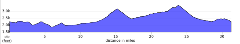
Starting at Mars Hill University, the first 10 miles is a series of warm-up hills through the rolling country of southern Madison County. This section follows the same route as the 100 mile Doggett Mountain Challenge and 100 kilometer Devil’s Fork rides. At Silvers Mill Road you split from the 100 mile century, crossing NC 213 the route tracks the West Fork of Bull Creek as it moves toward the mountains. The 4 kilometer climb to Grapevine Gap bounces above and below a 7% grade for a twisty ride to the top with dramatic views of the valley below. A long steep descent (with sharp hairpin turns!) leads to a T-junction with Big Laurel Road. The rest-stop is located at this junction. At the rest stop the course splits from the Devil’s Fork metric route. The Grind route turns right and follows Big Laurel creek upstream to the junction with US 23.
You rejoin the courses of the other rides near the Little Creek Cafe at the junction of Big Laurel Road and US 23. The gradual climb continues for a bit then tilts up for 2.5 kilometers to reach the top of Murray Mountain – a total rise of about 1,050 ft over the 6.6 miles since leaving the rest stop at the foot of Grapevine Road. Here you are only 7 miles from Mars Hill – starting with a much needed screaming descent and only one modest hill between you and the finish line.
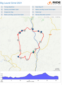
Click on map at right for printable map.
Click here for printable cue sheet.
This is not a ride for the faint of heart – riders will cover the 50 kilometer (31.2 mile) course and achieve a total ascent of 3,157 feet. We estimate the fastest riders will cover the course in under 2 hours and those taking it at a more moderate pace will finish within 3 hours.